Glasgow M8: How plans for Glasgow Inner Ring Road became part of M8


However, far from being a crucial artery linking Scotland’s west and east coasts, the initial stretch of M8 covered just four miles - effectively a bypass for Harthill.
The M8 had been mooted in the 50s as motorways popped up around the UK, as a means of easing pressure on the A8, which was the main link between Edinburgh and Greenock. A piecemeal approach meant it would be decades, though, before the M8 would become the road it is today.
Advertisement
Hide AdAdvertisement
Hide AdBut how did plans for an Inner Ring Road in Glasgow come to form part of the M8?
Bruce Report
The end of World War II was in sight and cities were thinking about the post-war age. One of the big questions is transport. Car usage was increasing year on year and it was obvious that the road network would struggle to cope.
Glasgow city engineer Robert Bruce delivered his First Planning Report to The Highways and Planning Committee in March 1945. His radical proposals would transform Glasgow - how people would live, where they would work, how the city centre could be developed, and how people could travel across the city.
Bruce described the current road network as “inadequate” and spoke about how traffic congestion was costing millions of pounds. And with more cars in Glasgow and road traffic casualties increasing, it became clear that action needed to be taken.
Advertisement
Hide AdAdvertisement
Hide AdHis plans included an Outer Ring Road - which would have extended around the outskirts of Glasgow - and an Inner Ring Road, following the outline of the city centre.
The report described the Inner Ring Road as a “gigantic roundabout” which would help the flow of traffic and ease pressure on the city centre streets.
The ring road would be created within a half mile radius of Central station with smaller roundabouts linking it to major roads around Glasgow. These smaller roundabouts - an idea perhaps ahead of its time - would have been two-tiered, with a bus stations in the middle in the centre of the upper tier, and shops and a tram station underneath.
The road plans were given the green light.
Stuck in limbo
Development plans produced in the ‘50s included many of the road proposals put forward by Bruce, including the Inner and Outer ring roads.
Advertisement
Hide AdAdvertisement
Hide AdHowever, as the decade went on little progress was made. Parts of the Outer Ring Road, including the Clyde Tunnel - the lack of cross river ‘communication’ in the west half of Glasgow was seen as a major defect - were given priority.
Later development plans brought up the Inner Ring Road, describing it as “essential”, and confirmed that it would be a urban motorway to help the flow of traffic. However, it would not be until the ‘60s that the plans for the Inner Ring Road would start to take proper shape.
A Highway Plan for Glasgow
In June 1965, Scott, Wilson, Kirkpatrick and Partners produced A Highway Plan for Glasgow - a definitive plan for the city’s road network that was not just thinking about the now, but the decades to come.
It was estimated that there were 138,000 vehicles in the Glasgow area in 1961, a figure estimated to reach 448,000 in 1990. Congestion was getting worse, with Pollokshaws Road, Anderston Quay, Great Western Road and Alexandra Parade the busiest routes at the time.
Advertisement
Hide AdAdvertisement
Hide AdThis ambitious plan featured 56 miles of new road at an estimated cost of £163 million. The plans built on previous proposals and detailed research on how people lived, worked and travelled.
The report detailed the outline of the Inner Ring Road and chose a route similar to the one included in the First Planning Report from 1945.
The scheme would see the Inner Ring Road linked to motorways and expressways around Glasgow - including the M74, which was being constructed at the time.
The Monkland Motorway would join the ring road to Edinburgh Road, while the Renfrew Motorway would link it to the west - both schemes would eventually become part of the M8.
Advertisement
Hide AdAdvertisement
Hide AdConcluding the report, the authors wrote: “The proposed Highway Plan cannot be completed for many years. Even if resources were freely available, the sheer size of the undertaking would require that it be constructed over a considerable period of time. In fact, resources are not freely available and the roads will be built just fast enough to contain the growing traffic volumes.”
Work starts
Final design work on the north and western parts of the Inner Ring Road had been commissioned before the Highway Plan for Glasgow had even been submitted. This stretch would join the Monkland and Renfrew motorways.
The report highlighted that the main priority was linking the motorways outside the city to the Inner Ring Road - and so the north and western sections of the Inner Ring Road would be included in the first phase of development.
It was hoped these could be opened in the mid-70s, with work on the southern and eastern parts of the Inner Ring Road forming phase two of the plan.
Advertisement
Hide AdAdvertisement
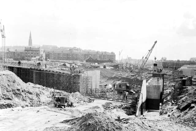
Hide AdWork started on the northern part of the road in 1965, with construction of the Kingston Bridge, Woodside and Charing Cross sections coming in subsequent years.
End of the scheme
The scale of the development brought widespread disruption. Meanwhile, the transformation of Charing Cross shocked many, including elected officials. Public opinion started to turn.
While the northern and western sections of the road would open in the early ‘70s, plans for the eastern and southern parts went back to the drawing board. But it wasn’t enough.
Other plans would be put forward, but Charing Cross would be the final section of the Inner Ring Road to open. The well-known ‘ski jump’ marks the place where the southern section should have started. The plans for the Inner Ring Road were dropped.
Advertisement
Hide AdAdvertisement
Hide AdHowever, work on the M8 had been progressing since the mid sixties. The section of the A8 between Newhouse and Baillieston brought the motorway to the edge of Glasgow.
Most of the motorway would be completed by 1980, with the Monklands and Renfrew sections completed in the late seventies.
Signs for the ‘ring road’ were still on the route in the late ‘80s, but it had now become just part of the M8.
Comment Guidelines
National World encourages reader discussion on our stories. User feedback, insights and back-and-forth exchanges add a rich layer of context to reporting. Please review our Community Guidelines before commenting.